This article is more than 1 year old
Upgrade eliminates Atlantis from Google Earth
Data glitch explanation won’t satisfy true believers
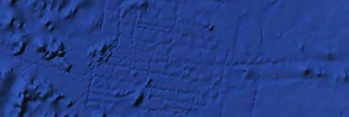
The latest update to Google Earth has resolved the software error that caused some to suspect the lost city of Atlantis had been found in the Atlantic Ocean.
For the last three years, Google Earth has shown what appears to be a grid on the sea floor between the Canary Islands and the mid-Atlantic ridge that bisects the ocean. After it was spotted, Google explained that the pattern was formed by a processing glitch caused by overlapping data sets, but that didn’t stop some internet denizens fond of tinfoil headgear from proclaiming that the image is proof that the legendary city existed.

Data glitch, or the largest city in human history?
Atlantis was first mentioned by Plato around 360BC. He spoke of a vast continent, larger than Libya and Asia Minor combined, lying just beyond the mouth of the Mediterranean. Plato never claimed to have seen the city, which supposedly sank beneath the waves in 24 hours, but instead claims to have heard of it as a story passed down over generations. The advent of the theory of continental drift and undersea mapping techniques has led to a waning of support, but there are still a few stubborn souls who believe the story.
The upgrade to Google Earth involved students identifying such cases and checking the data that produced the images. In the case of Atlantis, the image was formed by mixing a relatively low-quality scan of the sea bed, and overlaying that with the paths taken by sonar-carrying ships performing scans. Due to the scale of the images, the resultant “city” would have been the size of Wales – or New Jersey, for The Reg's stateside readers – making it the largest metropolis in recorded history, had it existed.
The undersea data for Google Earth comes from a variety of sources other than sonar, however. Around 90 per cent of the data on the ocean floor’s topology are taken from gravity measurements made from NASA’s Shuttle Radar Topography Mission (SRTM) rather than ship-mounted sonar, and this data will be upgraded next year with much more accuracy using the European Space Agency satellite called CryoSat.
To date, around 15 per cent of the ocean floor has been mapped to within one kilometer resolution for the Google Earth project, with the eventual goal being to explore the entire undersea landscape. It’s a sad fact that we know more about the surface of the moon than we do about our own terrestrial ocean-floor terrain. ®
